 |
 |
|||||||||||||||||||||
|
||||||||||||||||||||||
AZFO FIELD EXPEDITION
San Carlos River and San Carlos Lake
May 19-20, 2018
By DOUG JENNESS
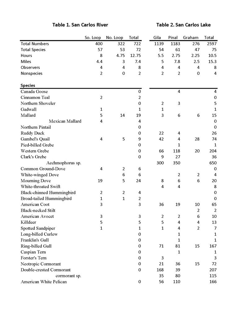
On 19-20 May eight participants surveyed the lower San Carlos River and San Carlos Lake. Both are located on the San Carlos Apache tribal lands, which were accessed by obtaining recreation permits. The principal aim of the expedition was to learn more about the riparian corridor along the lower San Carlos River. Thirty-seven miles long, the San Carlos River originates in the Natanes Mountains northeast of San Carlos Lake and merges with the Gila River at the east end of the lake. Most of the river's water comes from springs in mountain canyons, and in the upper part of the river water flow is year-round. However, much of the lower part of the river is frequently dry as a result of irrigation diversion. At the time of our survey, the river was not running, except in a few spots. A few patches of still water were also present. The river's elevation drops from 2550 ft to 2450 ft over the 5-mile stretch from where the survey began to where the river flows into the lake.
In November 2013, the AZFO organized an expedition to the same area to search for fall migrants and wintering birds from the north and from higher elevations (Jenness 2013). The May survey aimed to get a sense of the breeding birds and their density in the area, as well as find spring migrants. Of particular interest was breeding raptors, waterbirds, and Willow Flycatcher.
San Carlos River
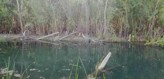 |
Figure 1. Beaver signs were found along the San Carlos River in many places. Photo by Keith Kamper |
On Saturday May 19, we organized two teams. The first started 1.2 miles south of US 70, where Coolidge Dam Road comes near the river; the second began at the river's mouth at San Carlos Lake and worked its way north. The northern team made a loop of about 3 miles, the southern team a loop of around 4 miles. The corridor is 0.25 mi to 0.5 mi. across so the return trips of the loops didn't result in overlap in counting. The river at this point serves as the boundary between Graham and Gila counties. Both teams' loops were on the west side of the river in Gila County. The habitats for the northern and southern survey tracts were different. The northern tract was dominated by large Fremont cottonwood (Populus fremontii), Gooding willow (Salix gooddingii), and tamarisk (Tamarix sp.). The southern section had large areas of small tamarisk, much of it dead, and acres of open fields covered with cocklebur (Xanthium sp.). However, long strips of healthy Gooding willow grew on moist soil slightly above the level of most of the surrounding land. There were no cottonwoods. On higher ground both areas had patches of mixed velvet mesquite (Prosopis velutina) and catclaw acacia (Acacia greggii). Evidence of beaver activity in both tracts included tree stumps, dams, and ponds (Figure 1).
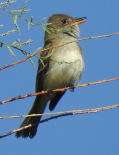 |
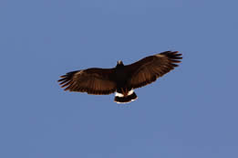
| Figure 2. A high concentration of Willow Flycatchers were detected along the San Carlos River. Photo by Brian Ison |
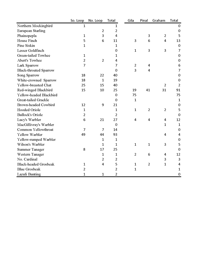
Of the 72 species detected during the day (Table 1), most noteworthy was the large concentration (n=32) of Willow Flycatchers (Figure 2). Both teams indicated that their counts were likely conservative as they were attempting to not double-count. Moving into a grove of willows we would immediately begin to hear them singing or making one of two typical calls from all directions. The southern team first detected a couple in tamarisk and then in willows near a large pond. However, the majority were in willows that were not adjacent to water. Most were in willows near water in the northern tract, although several were in adjacent tamarisk. The Northern Beardless-Tyrannulet, photographed in the northern tract, was towards the northern edge of its range (Corman 2005). However, it has been previously reported at the San Carlos sewage ponds near the San Carlos River and at Talkalai Lake, upstream of the river.
Most of the species observed were nesting in the area, either resident or recent arrivals. Most numerous was Yellow Warbler (n=93). Nesting was confirmed for 5 species: Vermilion Flycatcher (female sitting on nest), Brown-crested Flycatcher (begging young in cavity attended by adult), Bell's Vireo (adults near fledglings), Bewick's Wren (a couple of large family groups), Song Sparrow (adults building nest), and Yellow Warbler (adults feeding fledglings). Heron nests were detected in both tracts but appeared to be unoccupied. In the northern tract about 20 nests were in a grove of cottonwoods; in the southern tract a half dozen nests were in one of the stands of willow. Surprisingly, the only raptors reported were 2 Gray Hawks, 1 Cooper's Hawk, and 2 Red-tailed Hawks—presumably all nesting in the area. Zone-tailed Hawk, which has been reported frequently in the summer at San Carlos Lake, was not detected.
Spring migration was nearing its end, but a few migrants were seen. Among them were: Gadwall, Broad-tailed Hummingbird, White-faced Ibis, Western Wood-Pewee, Warbling Vireo, Tree Swallow, Violet-green Swallow, Pine Siskin, Green-tailed Towhee, White-crowned Sparrow, Black-headed Grosbeak, and Lazuli Bunting. The Lark Sparrows were likely migrants, but nesting in the area can't be ruled out.
San Carlos Lake
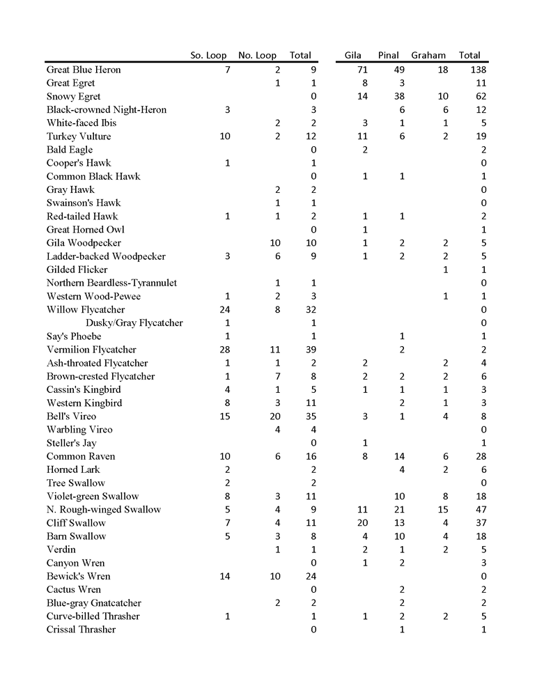
On Sunday 20 May, 2 teams surveyed San Carlos Lake—one along the north shore and the other along the south side. Unlike the riparian corridor along the river, the lake has been more regularly birded (Jenness 2017). However, its large size and irregularity of birder visits means that there are still many opportunities to make new discoveries. With two teams simultaneously visiting lookouts on both sides of the lake it was also possible to get a fuller picture of the number of birds present at the lake in May.
The lake, created in 1931 when construction of Coolidge Dam across the Gila River was completed, is one of the largest lakes in Arizona with a basin that is nearly 10 miles long (Figure 3). Although the entire lake is in the San Carlos Apache tribal lands, it is bordered by three counties—Pinal, Graham, and Gila. The water level varies considerably, depending on the amount of snowmelt in the Gila Mountains in New Mexico and summer monsoon rains. For this year's survey, the water level was the lowest for May since 2013 (USGS 2018). As a result, there were extensive mudflats and spits on both sides of the lake.
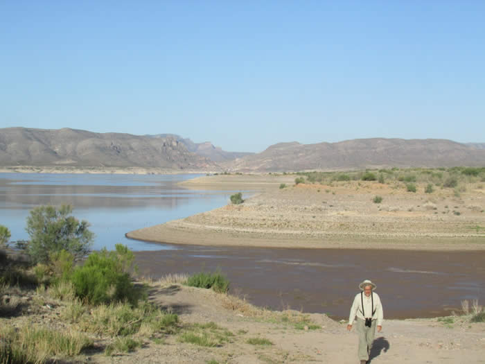 |
| Figure 3. San Carlos Lake looking west from the north side. Photo by Doug Jenness |
 |
| Figure 4. Steller's Jay was unexpected at San Carlos Lake. Photo by Keith Kamper |
 |
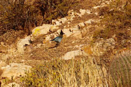
| Figure 5. Common Black Hawk may be nesting in the vicinity of the lake. Photo by Keith Kamper |
Of the 75 species reported (Table 2), the most surprising was a Steller's Jay (Figure 4), photographed near the dam. It was very late for this high-elevation bird to be in the lowlands, and it was the first time it has been reported at the lake. The nearest location where this bird is resident is the Pinal Mountains, nearly 20 miles away. A Common Black Hawk spotted later in the day at the same location had only been reported once before at the lake, just 2 weeks earlier at the same site (Figure 5). This suggests that a pair may be nesting, likely below the dam where there is running water. With the addition of these 2 species, the total number of species reported from the lake is 225.
Other than these new additions, the most remarkable observations of the day were the high numbers of several species. The 138 Great Blue Herons reported was a record number for May. This was likely due to the combination of scrutinizing more locations on each side of the lake and the extensive mudflats and spits. Such a large number suggests nesting in the area, and two small rookeries were found, both in the vicinity of the Soda Canyon Complex at the west end of the lake in Gila County. One rookery located in a grove of large eucalyptus trees contained 18 nests, 7 that appeared active. One nest had 2 adults and 2 fledglings, 1 had 2 downy nestlings, and 5 had one adult sitting or standing at the nests. The other group consisted of only two nests in cottonwoods, of which only 1 was active, with 2 adults present. The 167 Ring-billed Gull total was by far the highest reported for May. The total of 890 Aechmophorus grebes, an approximate number due to the difficulty of counting so many birds scattered over such a large area, was also a high for May. American White Pelicans are reported every month of the year at the lake. The fluctuating population includes migrants, wintering birds, and nonbreeding wanderers. The 166 reported during the survey is slightly more than the 150 observed two weeks earlier. This is the highest number seen in May at the lake. Photos of 2 pelicans with green wing tags were sent to the PELI Project and were confirmed by a biologist with the Utah Division of Wildlife Resources to have been tagged as juveniles in August 2017 on Gunnison Island in Great Salt Lake (Figure 6).
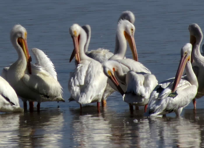 |
| Figure 6. White pelicans are found year-round at San Carlos. Bird with green wing tag was fledged in Utah in 2017. Photo by Diane Drobka |
This was only the second May that Canada Goose has been reported at San Carlos Lake. The 2 adult Bald Eagles reported were expected as several pairs nest at or in the vicinity of the lake and are frequently observed there year-round. Yellow-headed Blackbird is an expected migrant and wintering bird at San Carlos Lake. However, 20 May was a late date for this species, especially for a flock of 75, reported near the shoreline on the north side of the lake. The team that covered the south side of the lake spent some time at the mudflats at the far-east end in Graham County. It also visited Cottonwood Spring, a cottonwood oasis 2.5 miles east of the Pinal-Graham county line on the south side of Coolidge Dam Road. This accounts for the diversity of passerines, including migrants, reported from Graham County. The most surprising miss was Black Phoebe, which was not detected on either day at the river or the lake.
A special appreciation is extended to the participants for making this a successful and enjoyable trip : John Bartheleme, Diane Drobka, Brian Ison, Doug Jenness, Keith Kamper, Roy May, Craig Wilcox, and Erika Wilson.
Literature Cited
Corman, T. E. 2005. Northern Beardless-Tyrannulet in Arizona Breeding Bird Atlas. T. Corman and C. Wise-Gervais, eds. University of New Mexico Press, Albuquerque
Jenness, D. 2013. San Carlos Lake and San Carlos River, Nov. 9-10. AZFO. http://azfo.org/events/documents/SanCarlos2013.html
Jenness, D. 2017. Birding San Carlos Lake. AZFO. http://azfo.org/birding/documents/birding-san-carlos-lake-finalrevised.pdf
USGS. National Water Information Service.2018. https://nwis.waterdata.usgs.gov/az/nwis/uv
Table 1 and Table 2 PDF version here.
 |
 |
 |
|
©2010 |
HOME | | | REPORT SIGHTINGS | | | PHOTOS | | | BIRDING | | | JOURNAL | | | ABOUT US | | | CHECKLISTS | | | AZ BIRD COMMITTEE | | | EVENTS | | | LINKS |